Turquoise Lake
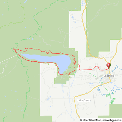
This is a very pretty loop on Route 9, 4 & 9C around a high alpine lake just west of Leadville. The loop around the lake itself is a 15 mile loop with 1,300' feet of climb on a quiet road. Be aware, though, that the road around the lake is rough in places so be careful and observant of conditions.
Park at any of the picnic areas or campgrounds around the lake if the lake loop is all you want to do. Generally we park at the Maid of Erin picnic area near the lake. From Harrison Street (Leadville’s main street) turn right on to West Sixth Street to a “T” at County Road 4. Make a right on to County Road 4 and drive almost all the way to the lake and the Sugarloaf Dam Site. From the Dam turn right onto Turquoise Lake Road (County Road 9C). Take your first left toward the Silver Dollar Campground. Maid of Erin Family Picnic Ground will be the first site on your left.
An alternative for a longer ride is to park across from the Safeway on US 24 outside of Leadville and ride out E. Mountain View Dr. for the loop around the Lake for a 22 mile, 1,900' climb ride. Our map link shows this ride starting from the Safeway.
Or ride from Breckenridge, Frisco or Copper Mtn over Fremont Pass to Leadville, around the lake and back. Breck to Breck is a challenging 100 mile Century ride with almost 8,000' of climb.
Click map for an interactive version and
downloadable GPS files.
Turquoise Lake

Turquoise Lake Loop
Turquoise Lake Elevation Profile

22 miles, 1,900' counter clockwise around the lake
Breck/Turquoise Century Elevation Profile


