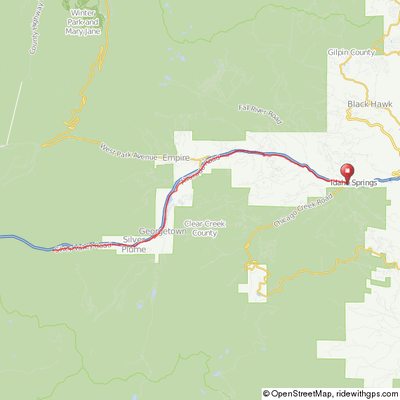
Georgetown/ Idaho Springs/ Bakerville (Optional)
This is a nice early or late season ride covering 24 miles and 1,200' of relatively gentle climb from 7,500' up to 8,500'. The start point is in Georgetown, about 25 minutes east of Summit County on I-70. Take Exit 228, turn right then take the first exit from the rotary and immediately look for parking along the right side of the road just past the Visitor Center. Do not park in the Visitor Center’s parking lot as there is limited parking there for patrons.
The route roughly parallels I-70 on secondary and some service roads. Take a little time to explore Idaho Springs when you arrive as well as Georgetown once you return.
You can also start in Idaho Springs and go the opposite direction if you prefer to do the uphill portion from the start. However, parking in Idaho Springs is very limited (cyclists cars have been ticketed in town in the past).
If you would like a little more distance and challenge, begin your ride in Bakerville (Exit 221) and ride downhill through the old mining town of Silver Plume to Georgetown then on to Idaho Springs. The route parallels Clear Creek and offers good views of the creek tumbling down through the gorge and mountainside.
This option adds 15 miles round trip and 1,420' of steeper climb for a total of 39 miles and 3,000' of climb. Note that Bakerville is little more than an exit off of I-70 and a parking area where the trail and jeep road to Gray's & Torrey's Peaks starts, so on your return fill water bottles, etc. at the Georgetown Visitor Center before beginning your climb back to Bakerville.
Idaho Springs - Bakerville
(Idaho Springs/Georgetown/Bakerville)
Click map for an interactive version and
downloadable GPS files.
There is very nice bike path beyond Bakerville for 5 miles to the Loveland Ski Area and access to the shorter east side of Loveland Pass.
If you prefer a lot more challenge, climb Guanella Pass out of Georgetown.
Elevation Profile
Idaho Springs to Georgetown

26 miles, 1,200' of climb
Elevation Profile
Idaho Springs to Bakerville


