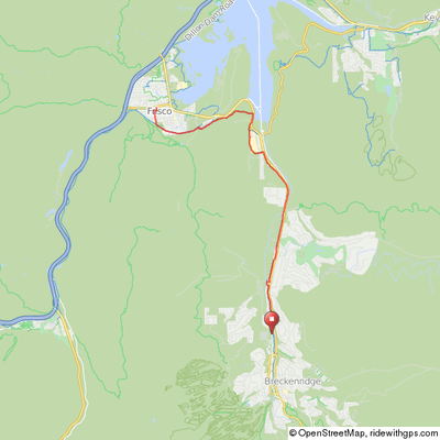
Breckenridge/Frisco
This is a good 17-mile out & back ride for kids because other than one short relatively steep hill south of the hospital, the trail is a very gentle grade downhill to Frisco (and uphill on the return!). The trail can be very busy with other bikers, inline skaters, and hikers so use caution. Many folks think it is a flat ride to Frisco and get fooled by the gradual but steady climb back to Breckenridge, often after a big lunch!
Although the path actually begins at the Breckenridge Transportation Center at the base of the town gondola, we recommend that you begin your ride at the Breckenridge Rec Center (where there is ample parking). The path parallels the Blue River and highway 9 for several miles where it crosses a few roads and driveways with traffic from the Building Center and Stan Miller Construction Company so use caution.
Breck/Frisco Out & Back
Bike Path to Frisco

Between the Medical Center & Frisco
As the trail approaches Farmer's Corner, it veers to the left around Summit High school and then passes beneath Highway 9 merging with a path coming from the right. Stay straight and follow the path about a mile to a “Y”. Take the left leg of the “Y” to pass back beneath Highway 9. The path then continues behind the Summit Medical Center and County Commons into Frisco where any of the turn offs to the right will lead to the Main Street in Frisco. As an alternative, you can take the right leg of the “Y” and head toward the Frisco Marina. If so, climb the hill, turn right at the “T” and follow the path through the Frisco Peninsula Recreation Area and to the Marina.
Click map for an interactive version and
downloadable GPS files.
Elevation Profile - Breck-Frisco

19 miles, 1,000' of climb

