Around Lake Dillon
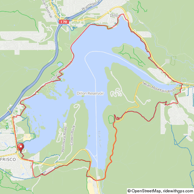
This 18-mile, 1,100' climb ride has one significant climb and descent over Swan Mountain on the south side of the lake. Note that the directions below are for a clockwise trip around the lake.
Start at the Frisco Marina or Dillon Amphitheater. Alternatively, go round trip from Breckenridge for a 31-mile ride with 1,600' of climb. In Frisco, the path starts across the street by the Frisco Cemetery and passes Ten-Mile River outlet, the Summit Middle School and marshlands with views of Lake Dillon. (read Frisco to Keystone ride for more info).
Just after the bike path bridge & before Swan Mountain Road between Dillon and Keystone, take a right at the “Y” in the path and follow the signs to Breckenridge for the continuation of the path in the Summit Cove subdivision.
Around Lake Dillon
Lake Dillon

The path will climb up Swan Mountain through the woods and descend briefly to where it crosses Swan Mountain Road and continues on the other side. Be careful at this intersection! Stop and look!
Once at the top at the Sapphire Point parking area, a walking path takes you to a spectacular view at Sapphire point. The bike path continues on the far side of the lot for about 200 yards before ending at the road. Descend in the downhill traffic lane with windy turns and intense speed.
At the bottom, just before the intersection with Route 9, turn right on the service road that passes along the left side of the water treatment plant. After about 200 yards, turn left onto the bike path and follow it around until it merges with the bike path coming from Breckenridge. Stay right here and follow the path about a mile to a “Y”. Take the right leg of the “Y” for the most direct route back to the Frisco Marina. Climb the hill, turn right at the “T” and follow the path through the Frisco Peninsula Recreation Area and back to the Marina. If you were to take the left leg of the “Y” you would pass beneath Route 9 and travel toward the Summit Medical Center and the south side of Frisco.
Click map for an interactive version and downloadable GPS files.
Elevation Profile
Clockwise from Frisco Marina

18 miles, 1,100' of climb

